P-cycle: 3 pools (DIP+DOP+POP)
This tutorial expands the previous 2-pool DIP+POP P-cycle to also track dissolved organic phosphorus (DOP). Phosphorus is conserved exactly across the three pools: every mole removed by any uptake or dissolution/remineralization is allocated to one of DIP, DOP, or POP. Both DIP and DOP are taken up by phytoplankton, and a shared fraction
We use the OCIM0 circulation.
using AIBECS
using JLD2                                        # required by `OCIM0.load`
using Unitful
using Unitful: m, d, yr, Myr, mol, mmol, μmol, NoUnits
import AIBECS: @units, units
import AIBECS: @initial_value, initial_value
The dissolved phases (DIP, DOP) ride the OCIM0 circulation; the particulate phase (POP) sinks with depth-dependent speed
grd, T_OCIM0 = OCIM0.load()
T_DIP(p) = T_OCIM0
T_DOP(p) = T_OCIM0
T_POP(p) = transportoperator(grd, z -> w(z, p))

function w(z, p)
    @unpack w₀, w′ = p
    return @. w₀ + w′ * z
end

z = depthvec(grd)
191169-element Vector{Float64}:
18.0675569520817
18.0675569520817
18.0675569520817
18.0675569520817
18.0675569520817
18.0675569520817
18.0675569520817
18.0675569520817
18.0675569520817
18.0675569520817
⋮
5433.2531421838175
5433.2531421838175
5433.2531421838175
5433.2531421838175
5433.2531421838175
5433.2531421838175
5433.2531421838175
5433.2531421838175
5433.2531421838175Uptake by phytoplankton (DIP and DOP), saturating in concentration and restricted to the euphotic layer
function U_DIP(DIP, p)
    @unpack τ_DIP, k_DIP, z₀ = p
    return @. DIP / τ_DIP * DIP / (DIP + k_DIP) * (z ≤ z₀) * (DIP ≥ 0)
end

function U_DOP(DOP, p)
    @unpack τ_DOPup, k_DOP, z₀ = p
    return @. DOP / τ_DOPup * DOP / (DOP + k_DOP) * (z ≤ z₀) * (DOP ≥ 0)
end
U_DOP (generic function with 1 method)Remineralization (DOP → DIP) and dissolution (POP → DOP), linear:
function R_DOP(DOP, p)
    @unpack τ_DOPrem = p
    return DOP / τ_DOPrem
end

function D_POP(POP, p)
    @unpack τ_POPdiss = p
    return POP / τ_POPdiss
end
D_POP (generic function with 1 method)The per-pool source/sink terms — note the shared
function G_DIP(DIP, DOP, POP, p)
    @unpack DIP_geo, τ_geo = p
    return @. -$U_DIP(DIP, p) + $R_DOP(DOP, p) + (DIP_geo - DIP) / τ_geo
end

function G_DOP(DIP, DOP, POP, p)
    @unpack σ = p
    return @. σ * $U_DIP(DIP, p) - $R_DOP(DOP, p) - (1 - σ) * $U_DOP(DOP, p) + $D_POP(POP, p)
end

function G_POP(DIP, DOP, POP, p)
    @unpack σ = p
    return @. (1 - σ) * $U_DIP(DIP, p) + (1 - σ) * $U_DOP(DOP, p) - $D_POP(POP, p)
end
G_POP (generic function with 1 method)Parameters:
@initial_value @units struct PmodelParameters{U} <: AbstractParameters{U}
    w₀::U        | 0.64   | m / d
    w′::U        | 0.13   | m / d / m
    τ_DIP::U     | 230.0  | d
    k_DIP::U     | 6.62   | μmol / m^3
    τ_DOPup::U   | 350.0  | d
    k_DOP::U     | 5.0    | μmol / m^3
    z₀::U        | 80.0   | m
    τ_DOPrem::U  | 0.25   | yr
    τ_POPdiss::U | 5.0    | d
    σ::U         | 1 / 3  | NoUnits
    τ_geo::U     | 1.0    | Myr
    DIP_geo::U   | 2.12   | mmol / m^3
end

p = PmodelParameters()
Main.PmodelParameters{Float64}
w₀ = 0.64 (m d⁻¹)
w′ = 0.13 (d⁻¹)
τ_DIP = 230.0 (d)
k_DIP = 6.62 (μmol m⁻³)
τ_DOPup = 350.0 (d)
k_DOP = 5.0 (μmol m⁻³)
z₀ = 80.0 (m)
τ_DOPrem = 0.25 (yr)
τ_POPdiss = 5.0 (d)
σ = 0.3333333333333333 ()
τ_geo = 1.0 (Myr)
DIP_geo = 2.12 (mmol m⁻³)Build and solve:
nb = sum(iswet(grd))
F = AIBECSFunction((T_DIP, T_DOP, T_POP), (G_DIP, G_DOP, G_POP), nb)
@unpack DIP_geo = p
x0 = DIP_geo * ones(3nb)
prob = SteadyStateProblem(F, x0, p)
sol = solve(prob, CTKAlg(), preprint = " ")
retcode: Success
u: 573507-element Vector{Float64}:
0.0017513873924220836
0.001777578834000493
0.0015888760790634256
0.0015217848497215843
0.0014595134192233437
0.0014299340631325316
0.0013724305380298006
0.0014628102906682713
0.0013715943941182245
0.0012942414529286321
⋮
2.7545992158331333e-9
1.936202063541435e-9
2.078970892332983e-9
2.8293522783868193e-9
2.909462497990013e-9
2.8247987797471838e-9
3.1012558158345998e-9
2.9854842005574325e-9
3.056094364278298e-9The sol value above carries the retcode, stats, and the residual norm — use it to confirm convergence before unpacking the state.
DIP, DOP, POP = state_to_tracers(sol.u, grd)([0.0017513873924220836, 0.001777578834000493, 0.0015888760790634256, 0.0015217848497215843, 0.0014595134192233437, 0.0014299340631325316, 0.0013724305380298006, 0.0014628102906682713, 0.0013715943941182245, 0.0012942414529286321 … 0.0015298321383126758, 0.0015306742248851074, 0.0015170079211880216, 0.0015170027463308807, 0.0021160095946224523, 0.002117396611849004, 0.002114381258709922, 0.0021055851016566346, 0.0021133312144984407, 0.00211617432420201], [0.0003883362185404378, 0.00038761213894674545, 0.00037217001346781135, 0.0003562432918415918, 0.0003273584585375639, 0.0003032257097091366, 0.0002877358627724638, 0.00027019066570967566, 0.0002830842984582961, 0.0002846554483452318 … 5.299125363256648e-8, 5.04743264305583e-8, 3.499506324873947e-8, 3.708486074921148e-8, 5.1867081900016373e-8, 5.4175017906469774e-8, 5.280290085792899e-8, 5.263491554811436e-8, 5.3133946293723525e-8, 5.543101618596354e-8], [1.6644999066513602e-5, 1.6859364214794638e-5, 1.5201768715429868e-5, 1.4555270082681296e-5, 1.3877982226724268e-5, 1.3499244460304522e-5, 1.2935070991651323e-5, 1.359238519848817e-5, 1.2902627279069797e-5, 1.2266426584571363e-5 … 2.952000470088496e-9, 2.7545992158331333e-9, 1.936202063541435e-9, 2.078970892332983e-9, 2.8293522783868193e-9, 2.909462497990013e-9, 2.8247987797471838e-9, 3.1012558158345998e-9, 2.9854842005574325e-9, 3.056094364278298e-9])We plot zonal averages of the 3 tracers (rows) across the Atlantic, Pacific, and Indian basins (columns), with one colorbar per row on the right.
using CairoMakie
using MakieExtra
using OceanBasins
using Unitful: ustrip
CairoMakie.activate!(type = "png")

Makie.get_ticks(t::Tuple{Any, Any},
                ::Union{MakieExtra.SymLog, MakieExtra.AsinhScale},
                ::Makie.Automatic, vmin, vmax) = t

OCEANS = oceanpolygons()
masks = (
    Atlantic = isatlantic(latvec(grd), lonvec(grd), OCEANS),
    Pacific  = ispacific( latvec(grd), lonvec(grd), OCEANS),
    Indian   = isindian(  latvec(grd), lonvec(grd), OCEANS),
)
basins = (:Atlantic, :Pacific, :Indian)

lat = ustrip.(grd.lat)
depth = ustrip.(grd.depth)
latticks = (-90:30:90, ["90°S", "60°S", "30°S", "0°", "30°N", "60°N", "90°N"])
maxdepth = ceil(maximum(depth) / 1000) * 1000

function wetlatrange(zm, pad = 5)
    haswet = [any(!isnan, view(zm, i, :)) for i in eachindex(lat)]
    wetidx = findall(haswet)
    isempty(wetidx) && return (-90.0, 90.0)
    return (max(-90, lat[first(wetidx)] - pad),
            min( 90, lat[last(wetidx)]  + pad))
end

function nicelevels(data; n = 10)
    hi = maximum(filter(isfinite, vec(data)))
    raw = hi / n
    mag = 10.0 ^ floor(log10(raw))
    nice = (raw/mag < 1.5 ? 1.0 : raw/mag < 3.5 ? 2.0 : raw/mag < 7.5 ? 5.0 : 10.0) * mag
    return collect(0:nice:(ceil(hi / nice) * nice))
end

function logishlevels(data; decades = 3)
    hi = maximum(filter(isfinite, vec(data)))
    hi_pow = Int(ceil(log10(hi)))
    lo_pow = hi_pow - decades
    candidates = sort!(vcat([0.0],
        [a * 10.0^k for k in lo_pow:hi_pow for a in (1.0, 2.0, 5.0)]))
    keep = candidates[candidates .≤ hi]
    if !(hi in keep)
        above = findfirst(c -> c > hi, candidates)
        above !== nothing && push!(keep, candidates[above])
    end
    return keep
end

ticklabel(x) = isinteger(x) ? string(Int(x)) : string(round(x; sigdigits = 3))
symlog_thresh(levels) = (nz = filter(>(0), levels); isempty(nz) ? 1.0 : minimum(nz))

zm_data = Dict(
    (:DIP, b) => ustrip.(u"μM", AIBECS.zonalmean(DIP * u"mol/m^3", grd, masks[b])) for b in basins
)
merge!(zm_data, Dict(
    (:DOP, b) => ustrip.(u"nM", AIBECS.zonalmean(DOP * u"mol/m^3", grd, masks[b])) for b in basins
))
merge!(zm_data, Dict(
    (:POP, b) => ustrip.(u"nM", AIBECS.zonalmean(POP * u"mol/m^3", grd, masks[b])) for b in basins
))

allvals(t) = vcat((vec(zm_data[(t, b)]) for b in basins)...)
levels_DIP = nicelevels(allvals(:DIP); n = 10)
levels_DOP = logishlevels(allvals(:DOP))
levels_POP = logishlevels(allvals(:POP))

xlim_basin = Dict(b => wetlatrange(zm_data[(:DIP, b)]) for b in basins)

rows = [
    (name = :DIP, levels = levels_DIP, base_cmap = :viridis, scale = identity,
     cblabel = rich("DIP (µM)")),
    (name = :DOP, levels = levels_DOP, base_cmap = :magma,
     scale = SymLog(symlog_thresh(levels_DOP)), cblabel = "DOP (nM)"),
    (name = :POP, levels = levels_POP, base_cmap = :cividis,
     scale = SymLog(symlog_thresh(levels_POP)), cblabel = "POP (nM)"),
]

fig = Figure(size = (1400, 950))
for (i, row) in enumerate(rows)
    cmap = cgrad(row.base_cmap, length(row.levels) - 1; categorical = true)
    cf_last = nothing
    for (j, b) in enumerate(basins)
        ax = Axis(fig[i, j];
            backgroundcolor = :lightgray,
            xticks = latticks,
            yreversed = true,
            limits = (xlim_basin[b][1], xlim_basin[b][2], 0, maxdepth),
            xautolimitmargin = (0.0, 0.0),
            yautolimitmargin = (0.0, 0.0),
            xlabel = i == 3 ? "Latitude" : "",
            ylabel = j == 1 ? "Depth (m)" : "",
            title = i == 1 ? string(b) : "")
        i < 3 && hidexdecorations!(ax;
            ticklabels = true, label = true, ticks = false, grid = false)
        j > 1 && hideydecorations!(ax;
            ticklabels = true, label = true, ticks = false, grid = false)
        cf_last = CairoMakie.contourf!(ax, lat, depth, zm_data[(row.name, b)];
            levels = row.levels, colormap = cmap, nan_color = :lightgray,
            extendlow = cmap[1], extendhigh = cmap[end],
            colorscale = row.scale)
    end
    if row.scale === identity
        cbticks = row.levels[1:2:end]
        Colorbar(fig[i, length(basins) + 1], cf_last;
            label = row.cblabel,
            ticks = (cbticks, ticklabel.(cbticks)))
    else
        Colorbar(fig[i, length(basins) + 1], cf_last;
            label = row.cblabel,
            ticks = BaseMulTicks([1]),
            minorticks = BaseMulTicks(2:9),
            minorticksvisible = true)
    end
end

for (j, b) in enumerate(basins)
    colsize!(fig.layout, j, Auto(xlim_basin[b][2] - xlim_basin[b][1]))
end

fig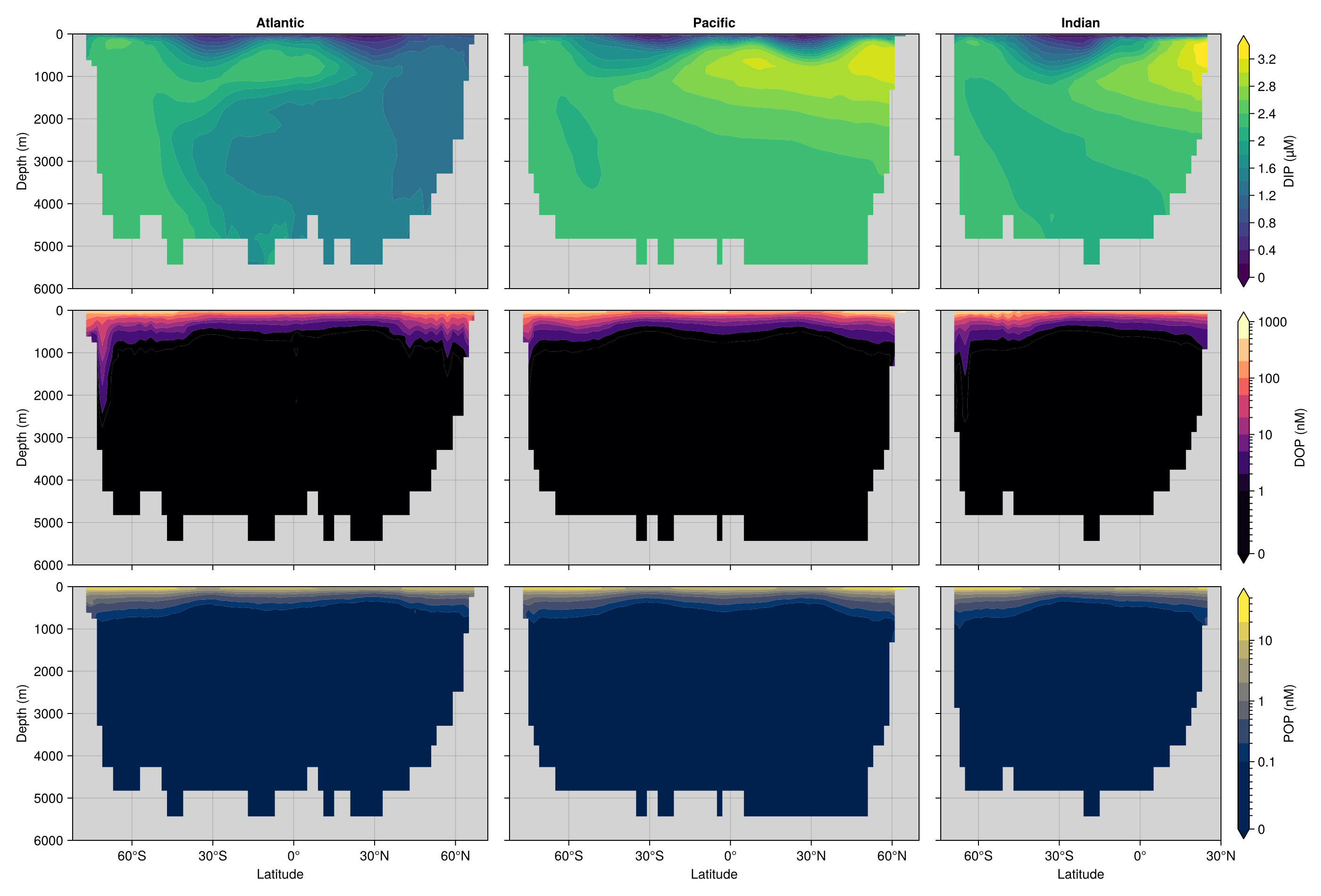
This page was generated using Literate.jl.